Tag: Guide

Holiday Gift Guide 2021: Travel Memoirs

Holiday Gift Guide 2021: Travel Memoirs

In 2020, reading about destinations gave us an outlet while staying at home. This holiday season, add new stories onto your list of armchair travel books with first-person accounts by travelers of various backgrounds. Here are some travel memoirs that make for both a great …

Travel Gift Guide 2021 – Paste

Travel Gift Guide 2021 – Paste

If 2020 was a year of staying home, 2021 will wind up as the year we got back out there. Travel has dramatically increased over the last few months, as confidence in vaccines and the need for a change of scenery have us itching to …

1941 WPA travel guide to post-Depression Arkansas tours an unfamiliar state

1941 WPA travel guide to post-Depression Arkansas tours an unfamiliar state


In 1941, Arkansas operated eight state parks. Seven were open only to white visitors. The eighth was set aside for the second-class citizens politely called Negroes.

Peaches were a major cash crop in Arkansas back then. At now vanished Highland Peach Orchard, south of Murfreesboro, nearly a million Elberta peach trees reached as far as the eye could see.

Fox hunting still took place in rural Arkansas eight decades ago, but without the English tradition of riding to hounds. Local hunters preferred to relax outdoors with a smoke and a drink while listening for the distinctive bark of each dog pursuing the fox.

Toby shows toured the state’s rural areas before World War II. The barker, known as “Toby,” would hawk candy boxes touted to contain tickets for winning a plaster elephant or some other gewgaw. Then he and a couple of supporting players would pass the hat as they entertained the crowd with homespun comedy.

And in Little Rock as the Great Depression ended, a dozen homeless families lived in shacks of scrap lumber and tar paper on a riverfront patch known as Squatters’ Island. Viewed as a tourist attraction, they grew tomatoes, okra, peppers and pumpkins in the alluvial soil.

Those time-warp nuggets and countless more are scattered among the lodes of information, much of it fascinating and some even amazing, in the 448 pages of “The WPA Guide to Arkansas.”

The book, created for the New Deal’s Works Progress Administration by a platoon of federally paid writers and editors, was printed in 1941. It was among the last of 48 state guides published, starting in 1937, by the agency’s much debated Federal Writers’ Project. The series also included the Alaska Territory, Puerto Rico and Washington, D.C.

Reprinted in 1987 with a fresh introduction as “The WPA Guide to 1930s Arkansas,” the original volume wafts today’s readers back to what was then the mainly rural “Wonder State” but soon to get a new nickname: “Land of Opportunity.”

Today, Bentonville has 54,164 residents and the 2020 Census estimated 546,725 residents in the Fayetteville-Springdale-Rogers metro area. Bentonville’s population in the 1940 U.S. Census was 2,359. Springdale’s was 3,319. Rogers’ was 3,550. Fayetteville’s was 8,212. The combined count of 17,430 in 1940 was handily surpassed by the 21,290 for Pine Bluff — then the state’s fourth largest city, now down to No. 10.

The guide’s 1987 edition can be bought online for $25 to $40 or read for free at some libraries (there are other reprints as well, including one by Trinity University Press in 2013). The 1941 original sells in some venues for hundreds of dollars. The contents portray Arkansas at a fracture point between the Great Depression and U.S. entry into World War II. Countless sights, often routine back then but vanished or altered now, flash by on the guide’s eight city tours and 17 driving routes (sometimes on unpaved state highways).

POTPOURRI OF TOPICS

Preceding the extensive touring sections are 19 essays on a potpourri of topics that shed light on public and private life eight decades back. Among the subjects are Natural Settings, Archaeology and Indians, History, Transportation, Agriculture, Recreation, Religion, Folklore and Folkways, Government, and Music.

In charge of the guide when the project began in 1938 were notable Arkansas literary figures Bernie Babcock and Charles J. Finger. They were soon replaced by Dallas McKown, who completed the process under the sponsorship of then-Secretary of State C.G. “Crip” Hall. The list of consultants mentioned 147 contributors.

“To obtain information for the guide, workers of the Arkansas Writers’ Project have haunted libraries, handled countless faded documents in archives, and have read hundreds of books, magazines and newspapers,” McKown wrote. “They have driven thousands of miles over highways that crisscross the Delta, slice through deep pine forests, follow river valleys, and ride the ridges of the Ozarks and Ouachitas.”

The Federal Writers’ Project drew persistent criticism nationally from conservative quarters, notably the House Un-American Activities Committee. Charges by the committee focused on alleged Communist connections or sentiments that were never substantiated. The accusations included the supposed promoting of racial integration, at a time when Jim Crow laws ruled the South and racial discrimination was widespread elsewhere.

“The WPA Guide to Arkansas” contains no evident sympathy for any easing of legal segregation — much less ending Jim Crow laws. Separate public facilities are mentioned as a matter of natural course, as with “Watkins State Park (for Negroes), 8.9 m. NW of Pine Bluff on U.S. 270.” The park is no longer on the map.

STEREOTYPES in 1941

Black communities are covered on the eight city tours and elsewhere in the guide. But urban Black people are often depicted in stereotypical terms as happy-go-lucky sorts looking mainly for a good time. Comments about rural Black people can be even more offensive, focusing on ignorance and superstitions. Reading them in 2021 would offend many readers of any skin color.

The guide also echoes some stereotypes about backwoods white Arkansans, as in these descriptions from a route through Newton County south of Jasper:

“The women wear sunbonnets, and many of them use snuff, taking a small quantity on the end of a ‘rough elm toothbrush,’ and chewing it like plug tobacco. Hill people consider dipping snuff, or putting it on the lower lip, an unclean habit, fit only for white trash and lowlanders.

“The men are weather-beaten and have tiny wrinkles about their eyes. Their loose-kneed, shambling gait is ungraceful, but deceptively fast, whether they strike out for town six or eight miles away, or are just making a circle to kill a few squirrels.”

MULE POWER

Arkansas agriculture was becoming more mechanized as World War II loomed, progress reflected in this tribute to the mule:

“Though their number has declined since tractors took over much of the level land, mules are still preferred to horses in cotton fields. The mule is tough, stubborn and wiry. He drinks water so muddy that a self-respecting horse would snort at it. He humps his back to a wintry wind and nibbles forage a mustang would scorn.”

On Saturdays, farmers and their families would head to the nearest town. Main Streets were the centers of shopping, well before the advent of shopping malls on arteries leading to interstates and other highways. This is what it was like in Blytheville:

“Main Street is a wide sunny avenue lined with brick stores and offices. Shoppers are most numerous on Saturdays. On this day, the stores put on extra clerks, barbecue and hamburger stands prepare for a rush, and the motion-picture theaters bill Western thrillers.

“Farm people pack the sidewalks to sell produce, buy groceries and drygoods, and meet their friends. Sacks of feed and coops of squawking chickens are piled high outside the stores at the eastern end of Main Street. Perhaps a huge catfish, fresh-hooked from a Mississippi slough, dangles before a lunchroom.”

Hot Springs was also lively as it welcomed tourists, but with leisure activities mostly different from today:

“Outdoor photograph studios, where visitors have their pictures taken astride a slumbering burro or behind a prop saloon bar, spring up in vacant lots next to sumptuous hotels. Small shops serve fresh seafood, fruit juices or goat’s milk. Stands display crystals, curios, souvenirs and trinkets. In the narrow canyons, patrons of shooting galleries blaze away into the mountainside.”

The guide’s 1987 reprint added a new introduction by Elliott West, a University of Arkansas, Fayetteville historian. He asserted that “if there is a common theme uniting the past and the present and the state’s various parts, it is that of poverty.”

That is less true in 2021 in the state’s metropolitan areas, but it remains a lamentable fact of life in many small towns and rural areas. Per-capita income in Arkansas today ranks 45th among the 50 states.

RHAPSODIES

But the opening pages of the original edition cite Arkansas’ non-monetary treasures. These other avenues of pleasure are described in rhapsodic terms, which curmudgeonly readers might view as saccharine:

“Part of the wealth of Arkansas today is not in its minerals and forests, but in the sights and sounds encountered by a visitor.

“It may be the small thunder of a covey of quail that he will remember longest, or a flight of mallards wheeling down into a swamp because of a hunter’s expertly rendered call, or the bright glow of straw stacks burning in the rice fields after threshing time. The zigzag rail fences overgrown with honeysuckle, the clear smokeless air in the cities, the tumbling of the mountains eastward from Winslow, the smell of wood smoke from a great stone chimney at the end of a cabin, the pungency of pine sawdust and the whine of the saw biting into a log, the clumps of mistletoe in leafless trees.

“You won’t forget these things soon, even though they are not the important aspects of Arkansas, where the politeness of the South and the friendliness of the West are both responsible for the personal tone in ‘Y’awl hurry back.'”
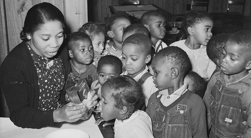
It was time for cod liver oil in the nursery school when Farm Security Administration photographer Russell Werner Lee (1903-1986) visited the Lakeview Resettlement Project, 15 miles southwest of Helena, in December 1938.
(Library of Congress Prints & Photographs Division)

It was time for cod liver oil in the nursery school when Farm Security Administration photographer Russell Werner Lee (1903-1986) visited the Lakeview Resettlement Project, 15 miles southwest of Helena, in December 1938.
(Library of Congress Prints & Photographs Division)

Your 101 Guide to Ice Climbing

Your 101 Guide to Ice Climbing

“],”renderIntial”:true,”wordCount”:350}”> Here’s the very first issue you want to know about ice climbing: it is not as challenging as it seems. Of course, you are scaling a vertical frozen waterfall with sharp metallic objects on your toes and in your palms, but some say it …

Your Guide to When, Where, & How

Your Guide to When, Where, & How

As fall and winter breaks approach, there’s still hope for a great getaway even if you haven’t booked anything yet. share this article For many travelers, the 2020 holiday season was a bust (thanks, COVID). Does it have to be that way this year? Lingering …

The Ultimate Road Trip Guide to California’s Highway 395

The Ultimate Road Trip Guide to California’s Highway 395

“],”renderIntial”:true,”wordCount”:350}”>

I’ve been driving California’s Highway 395 since I was a kid, first as a preteen ski racer in the passenger seat of my mom’s Subaru, en route to races at Mammoth Mountain. Later, as a twentysomething ski bum living in Tahoe, I’d drive it with friends for a weekend of backcountry skiing or rock climbing on the eastern side of the Sierra. Now, I head out in a camper van to find deserted campsites, hot springs, and hikes to alpine lakes with my two kids in tow. Every time the car is pointed south on 395, I know good times lie ahead. 

Sure, California’s coastline and its iconic roadways like Highway 1 and 101 are gorgeous and get the most attention. But I’d argue that Highway 395 makes for a more adventurous, off-the-beaten-path long-weekend road trip than any other in the Golden State. After all, this is the main access point to the eastern edge of the Sierra Nevada, where the wall of high-altitude peaks looks as dramatic as the Alps from every vantage point along the way.

The highway connects Reno, Nevada, and the Lake Tahoe area on the northern end to Los Angeles on the southern end. From those endpoints, it’s 262 miles. We start our guide and mile-marked road map from the northern point. Along the way, you’ll pass by 14,505-foot Mount Whitney, the tallest peak in the lower 48; Mono Lake, a million-year-old saltwater lake; and plenty of roadside hot springs. This is the best of the West, all on a single highway. Here’s when to drive it, where to stop, and how to find your own path.

When to Drive Highway 395

There’s no bad season on 395. But when you should go depends on what you’re after. If hiking, climbing, or biking are your jam and you don’t want to deal with winter driving conditions, come in summer or early fall, when temperatures are mild and lakes are cool but swimmable.

If you’re a skier, winter and spring are prime time here. You’ve got ski resorts like Mammoth Mountain and June Mountain, both on the Ikon Pass, just off the highway. For experienced backcountry skiers, the terrain in this zone is world class, with steep couloirs and low-angle trees out of the Virginia Lakes and Bridgeport areas and spicy classics like the Bloody Couloir and Dana Couloir farther south, near Mammoth. Keep in mind that the roadway can be snowy and icy from November to April, and many of the neighboring mountain passes that access this road from points elsewhere, like Tioga Pass and Sonora Pass, are closed in the winter. 

Where to Stop

Mile 115: Bridgeport

(Photo: CampPhoto/iStock)

If you’re heading south, there’s not much in the way of towns after Bridgeport for a stretch, so fill up on gas and load up on burgers and milkshakes at The Burger Barn, a walk-up window with patio seating and tasty waffle-cut sweet potato fries. Buckeye Hot Springs, alongside the scenic Buckeye Creek, is a few miles down a side road from Bridgeport. There’s dispersed camping near the springs, as well as an established first-come, first-serve Forest Service campground at Buckeye Campground (from $20), which is open from May to September. Travertine Hot Springs is just south of town. High Sierra Snowcat and Yurt runs a guided backcountry ski operation out of the Virginia Lakes area in winter, as well as summer backpacking. 

Mile 122: Bodie State Historic Park

(Photo: Kenzo75/iStock)

If you’ve ever wanted to see what an actual ghost town looks like, stop at Bodie. Take the ten-mile detour off Highway 395, just south of Bridgeport, to Bodie State Historic Park. This former mining boomtown had its heyday between 1877 and 1881 and was known as one of the wildest and roughest mining camps in the West, until its thousands of former residents fled in a hurry following a fire. Though the incident damaged much of the town, plenty of structures are still intact, like the old schoolhouse, barbershop, and dozens of other buildings.  

Mile 140: Mono Lake Tufa State Natural Reserve

(Photo: XIN WANG/iStock)

As you drive Highway 395 south of Bodie, you’ll come down a steep, curvy hill with views of Mono Lake. The landscape looks like it belongs on Mars. Tall calcium carbonate spires rise from the shores of an ancient, mythical-looking saline lake. This 65-square-mile lake is more than twice as salty as the ocean, so if you’re brave enough to take a dip, you’ll float as if on a gravity-free planet, and legend has it the minerals in the water can cure whatever ails you. (Pro tip: Bring a bucket of fresh water to rinse off with.)

Afterward, stop at the Mobile gas station in the town of Lee Vining, where the Whoa Nellie Deli, open only during the summer months, is officially the best restaurant that ever existed inside a gas station. People drive over from Yosemite National Park, 12 miles up Tioga Pass, just for the fish tacos. You can also load up on supplies, souvenirs, or basic grocery items. There’s often live music near the outdoor picnic tables during summer.  

For a detour during the summer months (Tioga Pass is closed in winter), the stunning drive into Yosemite is well worth it. Make sure you have a reservation if you’re going into the park during peak season, but if you don’t, there are great day hikes outside the Yosemite entrance gate, like the trails to Glacier Canyon or Fantail Lake, or go for a dip in Tioga Lake, just before the park gates. You can score first-come, first-serve campsites all along Tioga Pass at sites like Saddlebag Lake Campground (from $24) or Junction Campground (from $14). In spring, backcountry skiers flock to this road once it’s open, usually in late May, for skiing lines like Mount Dana or North Peak.

Mile 154: June Lake

(Photo: michaelschober/iStock)

You’re not in a rush, right? Take the scenic way around on the June Lake Loop, a 16-mile drive just off Highway 395 that connects four striking lakes (be sure to stop for the view at Silver Lake) and the quaint town of June Lake. Grab a pint and some tacos at June Lake Brewing. The 3.8-mile round-trip hike to nearby Parker Lake has stellar fall foliage or summertime lake swimming.   

Mile 169: Mammoth Lakes

(Photo: LifeImagesbyGloria/iStock)

The town of Mammoth Lakes makes for a great overnight stop. In summer, ride the gondola to the top of Mammoth Mountain and mountain bike or hike off the 11,053-foot summit. In winter, this volcanic peak boasts 3,500 skiable acres and 25 lifts that access a wide variety of terrain. 

In Mammoth, hit up Stellar Brew for coffee and breakfast burritos, Dessert’D Organic Bake Shop for the best chocolate chip cookies in town, and Campo, in the village, for pizza and cocktails. Post up lakeside at Tamarack Lodge (from $119), or head just south of town for quaint lakefront cabins at Convict Lake Resort (from $129).

Natural hot springs are scattered south of town off Benton Crossing Road. Start with tubs like Wild Willy’s or Hill Top. If they’re full, drive around until you find an empty one. 

Mile 205: Bishop

(Photo: epicurean/iStock)

Climbers come to Bishop for the famed Owens River Gorge, a deep canyon over the Owens River that’s packed with bolted sport-climbing routes. There’s also bouldering on the massive house-sized rocks that dot the Buttermilk Range. Sierra Mountain Guides leads guided rock-climbing outings in the Bishop area. Not a climber? Hike to high-alpine lakes like Lamarck Lakes or Sabrina Lake.  

Afterward, get in line for a sandwich or a loaf of bread, originally from a Basque sheepherder’s recipe, at Schat’s Bakkery in Bishop.

Mile 262: Lone Pine

(Photo: benedek/iStock)

Lone Pine has been the setting for hundreds of classic Western movies over the years, thanks to its high-desert vibes and not-too-far-flung location three hours from Hollywood. Nowadays, it’s become a destination for climbers set on summiting Mount Whitney, which towers over town. The local climbing and mountaineering store, Elevation, has fuel tanks for your camp stove, climbing gear, or whatever else you need. Start your day at the Alabama Hills Cafe, a hole-in-the-wall breakfast spot with big, gooey cinnamon buns. 

Drive up Whitney Portal Road to take in the view of the highest peak in the lower 48. Sierra Mountaineering International leads guided climbs up Mount Whitney, but bear in mind that a summit bid is a big endeavor and requires advance permitting. You can take an easier day hike up a lower section of the Mount Whitney Trail—Pine Lake is 2.8 miles up the trail and makes for a great picnic spot.  

Whitney Portal Hotel and Hostel (from $33) has bunks and basic rooms geared toward climbers. Otherwise, the Alabama Hills Recreation Area is BLM land with beautiful, free dispersed camping set among massive boulders with a view of Mount Whitney. There’s also a designated campground at Whitney Portal. 

From Lone Pine, the road continues south, with Los Angeles just a few hours ahead.